Historic Black Hawk Peak Area, Gilpin County, Colorado

posted in: Harder Hikes | 0

If you have ever done the Rocky Mountain National Park hikes to Lulu City or Eugenia, congratulations, you hiked to a sign!

If you want to see actual historical remnants, you need to travel south a bit to an area where the hiking guidebooks don’t quite reach. The area is Gilpin County.

There is a tremendous amount of history in Gilpin County from the mining and pioneer days. And luckily, many historical areas are off the beaten path just enough that they are preserved for hikers like you and I.

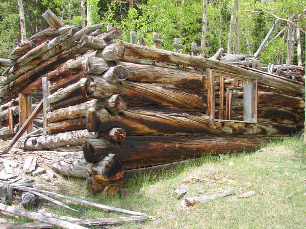
This trip contains 2 destinations: The hike to the summit of Black Hawk Peak is a rewarding bushwhack in itself, but you can also travel to an old mining town site and see cabin remains, the springs that fed them, and ascend to the top of mine tailings for the best views of the trip. Look around this area for a while and you will find more and more interesting facts of the lives of these rugged individuals. This area is on the outskirts of a town known as Wideawake back in the mining days. I hope you will find it as fascinating as I did.

Your hike begins at the entrance to the Pickle Gulch group picnic area. There is some room to park off to the side of the road. The hike up the old road is steep and covered in gravel/talus. The descent is harder than the ascent due to the slippery nature of the road. It’s amazing that Colorado’s early pioneers traveled this difficult road in the equipment of the time. Once you reach the point marked “overgrown rds”, you have overcome the most difficult part of the trip, and you have the choice of heading left up to Black Hawk Peak or straight ahead to the old town site. Be sure to see them both while you are up there.

Download Blackhawk Peak Tracks and Waypoints (158 downloads)

Herman Lake Trail near Georgetown

posted in: Harder Hikes | 0

This hike begins off the side of I-70 at exit 218 (right before the Loveland Pass exit) and ascends through a wildflower valley to Herman Lake, a high-mountain lake with water cascading into it off of multiple surrounding peaks. Much of the route is on the Continental Divide Trail, which crosses under I-70 at this trailhead.

This is a very picturesque hike in itself, but if you are spending some time in the immediate area you may want to bag Grey’s and Torrey’s Peaks also, a pair of adjacent 14’ers that are nearby. I have the tracks for that hike in a separate article on this site.

The Herman Lake hike gets quite crowded on the weekends, at least for a National Forest hike. Nowhere near as bad as a comparable Rocky Mountain National Park hike, but still, you will not find much solitude on summer weekends here. Weekdays are desolate though, and you are only within earshot of the Interstate for a short time.

This hike is a very popular one for Internet bloggers to try to describe, so there is incorrect information about this hike all over the Internet. Wrong turns, wrong mileages, you name it. It’s a 6.7 mile round trip, and the track download will make sure you don’t make a wrong turn:

Download Herman Lake Tracks and Waypoints (160 downloads)

James Peak via Loch Lomond

posted in: Harder Hikes | 0

So it’s not quite 14,000 feet. Believe me, you will earn this summit. The Loch Lomond route to James Peak is a fairly steep ascent to the summit of a very prominent Continental Divide 13’er. This mountain serves as the intersection of Gilpin, Clear Creek, and Grand counties, and the views on the trip up are almost as rewarding as the views from the summit itself. On the way up you pass a total of 5 lakes, with the aptly named Ice Lake as the highest. Once on top, the Mary Jane ski runs at Winter Park will appear so close that it looks as if you can reach out and touch them, but watch out for the updraft on that side of the mountain!

The approach can be an adventure in itself. The Forest Service road up to the Loch receives very little maintenance and has deteriorated to a very slow 4×4 rock crawl. You can choose how far you want to drive before you strike out on foot. Your vehicle may make the decision for you. The first parking area on the route can be accessed by most vehicles without any difficulty, although the ride will be bumpy. Beyond that, you will need a high-clearance vehicle with 4×4 Low Range to go any farther. Camping at 11,000 feet+ is an experience not to be missed. Sites abound along the road just before you hit treeline. Some people camp above treeline at the Loch itself, but if there is even a chance of stormy weather I prefer to stay a little lower.

I have divided this trip into 2 tracks. The first track starts at I-70 and guides you through the St. Mary’s roads and then up the Forest Service road to Loch Lomond. The second track starts at the Loch and ascends the actual trail to the summit.

Some years, accessibility to this route has been a huge problem, it just depends on the snowpack and spring temperatures. You may find snowfields blocking the trail in places if you go early in the season, I always prefer to go around them rather than across. I’ve fallen through a snowfield before and it isn’t easy to get back up, so just because you see footprints going across doesn’t mean you should try it.

Did I mention the solitude? Very few people know about this peak, so if you’re looking for some quiet time on a high mountain peak, this is it. Of the few people that know about this peak, most of them approach it from an easier but less scenic route to the North. So you will likely encounter very few people, if anyone, once you get above the Loch. There is a circular rock shelter on the summit to help you stay out of the wind while you enjoy your time on top of this magnificent Continental Divide 13’er.

Download James Peak Loch Lomond Tracks and Waypoints (165 downloads)

Gregory Canyon Saddle Rock Loop, Boulder.

posted in: Harder Hikes | 0
The flatirons area in Boulder has amazing foothills hiking. Follow this track to get a good sample of everything the flatirons area has to offer. This hike crosses Chautauqua Park and proceeds to the parking area for Gregory Canyon (you can park at the parking lot if you want a shorter trip, but a fee is charged). It then completes a steep, but short, loop through the Gregory Canyon area along the Saddle Rock Trail.
  Download the tracks and waypoints:   If you are not quite sure how to get the routes and waypoints to open correctly, read the FAQ on the subject for help: Downloading Routes And Waypoints FAQ.   If you would like to spend the night in Boulder, there are a multitude of modern hotels, or stay in one of the Chautauquas. If you’d like to go into the mountains a bit further you can head west to Nederland for a reasonable mountain hotel. There really isn’t any camping in the area near Boulder until you get near Estes Park.

Download Gregory Canyon Tracks and Waypoints (165 downloads)